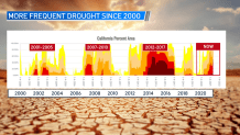
Some sort of drought is part of the cycle over the west but it’s the frequency of drought and intensity that has really started to change the past 20 years with our increasing temperatures and changing climate.
It may come as a surprise or even eye opening when you look at the data below. You can see we’ve had more years with drought conditions than without. This includes the years of 2001-2005, 2007-2010, 2012-2017, 2018-2019 and our current drought that started to ramp back up in 2020.

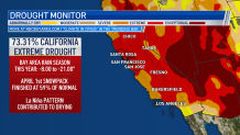
As you can see in the photo below, the latest drought has also started to become worse as most of California 73.31% is covered in “extreme” drought and this includes the Bay Area. Two horrible rain and snowpack seasons in a row are to blame. This year we are running -8.00 to -21.00” behind on rainfall and our Sierra snowpack only finished at 59% of normal.

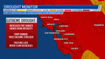
So what does “extreme” drought bring? Increased fire danger with a higher burn intensity, crop damage, trees are stressed and lower river flows.

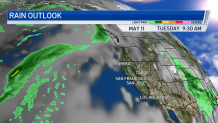
What about our rain chances ahead? You’ll see in the image below there’s rainfall in the Pacific that looks promising but unfortunately it’s expected to move well north of the Bay Area. At this point we are really starting to see our rain season end as we move into our typical dry months starting in June through September.

You can find out more about how the Bay Area climate is changing in a series of stories the Microclimate Weather Team worked on across the Bay Area.
Get a weekly recap of the latest San Francisco Bay Area housing news. >Sign up for NBC Bay Area’s Housing Deconstructed newsletter.


