Starting Monday, the National Weather Service will add new “damaging threat” categories when severe thunderstorm warnings are issued.
The hope is that these categories will better convey the severity and potential impacts of severe thunderstorms to the public. Tags like these already exist for tornado and flash flood warnings.
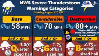
There are three categories: destructive, considerable and baseline.
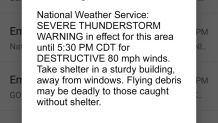
DESTRUCTIVE damage threats will be triggered when there is at least baseball size hail (2.75 inches in diameter) and/or 80 mph winds. This category is the highest damage threat, and will also automatically activate a Wireless Emergency Alert on smartphones within the warned area.
CONSIDERABLE damage threats will be triggered when there is at least golf ball sized hail (1.75 inches in diameter) and/or 70 mph winds. This will NOT activate a Wireless Emergency Alert on your smartphone.
BASELINE or “base” damage threat remains unchanged, and is triggered when there is quarter sized hail (1 inch in diameter) and/or 58 mph winds. This will NOT activate a Wireless Emergency Alert on your smartphone. If a severe thunderstorm warning is issued, damage is considered to be baseline unless otherwise indicated.
Of course, seeing a destructive alert on your phone may be a bit jarring – but per the National Weather Service, on average, only 10% of all severe thunderstorms reach this category each year across the country. The addition of these categories will convey to the public when immediate action is necessary due to a life-threatening situation.
U.S. & World
The safest place to be during a severe thunderstorm is indoors, away from windows.
Click here for other ways to stay safe when a severe thunderstorm warning is issued.
Get a weekly recap of the latest San Francisco Bay Area housing news. Sign up for NBC Bay Area’s Housing Deconstructed newsletter.


