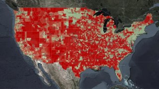
For the first time, a federal agency has released a comprehensive online map clearly depicting what experts have long warned: Many parts of America — largely in poor, rural and tribal areas — lack quality and affordable broadband internet access.
The National Telecommunications and Information Administration, part of the Department of Commerce, published the map Thursday. The interactive online graphic combines data from a variety of sources both public and private: speed test data provided by M-Lab, Ookla and Microsoft, as well as overlays of census data.
The map offers some granular views of internet access in communities across the United States. It shows that in one largely working-class and Latino census tract in east Oakland, California, more than 26 percent of people do not have household internet access despite having commercial providers. The cost of internet access can often be a barrier for low-income households.
Meanwhile, just a few miles to the north, in a generally wealthier and whiter neighborhood, that figure falls to just 6 percent.
Read the full story at NBCNews.com.
Get a weekly recap of the latest San Francisco Bay Area housing news. >Sign up for NBC Bay Area’s Housing Deconstructed newsletter.

