NBC Universal, Inc.
Around the country, people rely on these piles of snow for their water supply. What is a snowpack, and how else does it impact you?
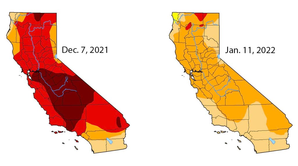
January rain and snow in Northern California and ample snowpack from a series of early winter storms helped ease the worst drought conditions in California.
This week's U.S. Drought Monitor report shows no part of California in the most severe Drought Monitor category, known as exceptional drought. Three months ago, about 45 percent of the state was in exceptional drought.
Northern California received several inches of precipitation over the last week, adding to rain and snow from several storms in December.
The U.S. Drought Monitor map for Thursday Jan. 13, 2022.
This week's drought reports also shows improvement in other less severe categories. Extreme Drought, the second most severe category, was reduced to a few small patches in Northern California.
"Based on the abundant precipitation and ample snowpack observed so far this winter, improvement was brought into several areas," according to the Drought Monitor summary. "Most notably, most of the large D3 (extreme) area covering interior portions of northern and central California were reduced to D2 (severe)."
Nearly all of the state remains in moderate to severe drought.
These maps show drought conditions in California Jan. 7, 2021 and Jan. 11, 2022. Credit: US Drought Monitor
“When we started December, we were in extreme drought conditions,” said NBCLA forecaster Belen De Leon. “But Mother Nature was good to us in December, we had storm after storm."
Droughts are common in California, where dry spells are often followed by wet winters that replenish the state's critical snowpack and water reservoirs. And it takes more than a lot of rain and snow in one shot to ease drought conditions.
The state is “definitely not out of the woods quite yet," said Sean de Guzman, manager of the snow surveys and water supply forecasting for the California Department of Water Resources.
Caltrans
The State Highway 89 roundabout in Tahoe City is pictured Thursday Dec. 30, 2021.
NBCLA
The 5 Freeway was closed north of Los Angeles Thursday Dec. 30, 2021.
FOREST FALLS, CA – DECEMBER 28, 2021: Sam Richey, 15, of Forest Falls gets some air-time while using a Boogey board to sled on fresh snow from Mondays winter storm on December 28, 2021 in Forest Falls, California.(Gina Ferazzi / Los Angeles Times via Getty Images)
Getty
Tustin, CA – December 26: Sun and clouds paint the sky over Orange County on Sunday, December 26, 2021 as storms are expected to close out the year. Rain and snowfall of 4 to 8 inches is anticipated at elevations above 4,000 feet and up to 16 inches above 6,500 feet Monday into Tuesday. (Photo by Mindy Schauer/Digital First Media/Orange County Register via Getty Images)
NBCLA
Snow in the mountains east of Los Angeles Wednesday Dec. 29, 2021.
FOREST FALLS, CA – DECEMBER 28, 2021: A man takes a selfie amidst the snow covered San Bernardino National Forest after Mondays winter storm dropped snow to the 5,000 foot level blanketing Forest Falls in a white winter scene on December 28, 2021 in Forest Falls, California.(Gina Ferazzi / Los Angeles Times via Getty Images)
Torrance, CA – December 28: With a break from the rain but cold temperatures and bright sun, the ocean almost looks like snow at the beach in Torrance on Tuesday, December 28, 2021. Showers are forecasted to return Wednsneday and Thursday but New Year”u2019s Eve celebrations should be under clear skies. (Photo by Brittany Murray/MediaNews Group/Long Beach Press-Telegram via Getty Images)
CHP
A storm closes part of Interstate 80 in the Sierra Nevada Mountains Dec. 25, 2021.
Caltrans
Caples Lake Maintenance crews clear snow on State Route 88 on Christmas Eve in Alpine County.
Caltrans
Caltrans crews clear snow in the mountains of Inyo County on Christmas Day.
Silverado Canyon, CA – December 24: A mudslide-covered propane tank sits along Silverado Canyon Road in Silverado, located in eastern Orange County, following an overnight storm, on Friday, December 24, 2021. The December 2020 Bond fire burned much of the the area and left the hills above the canyon barren and vulnerable rock-filled mudslides. (Photo by Mark Rightmire/MediaNews Group/Orange County Register via Getty Images)
SILVERADO CANYON, CA – DECEMBER 23: Jay Parker, 40, stands where his yard was washed away, the hot tub covered with mud and oak trees were toppled by a flash flood during last weeks storm along the 28000 block of Silverado Canyon Road on Thursday, Dec. 23, 2021 in Silverado Canyon, CA. (Gary Coronado / Los Angeles Times via Getty Images)
Caltrans
Caltrans crews clear snow in the mountains of Inyo County on Christmas Day.
Getty Images
Los Angeles, CA – December 23: Cars drive through a rain flooded intersection at Chastsworth St and Haskell Ave in Granada Hills, CA, Thursday, Dec 23, 2021. (Photo by Hans Gutknecht/MediaNews Group/Los Angeles Daily News via Getty Images)
Los Angeles, CA – December 23: A pedestrian makes his way along Van Nuys Blvd at Arleta Ave in Arleta, Thursday, Dec 23, 2021. (Photo by Hans Gutknecht/MediaNews Group/Los Angeles Daily News via Getty Images)
LOS ANGELES, CA – DECEMBER 21: Snowcapped mountains are seen in the distance from City Terrace on the first day of winter in Pasadena on Tuesday, Dec. 21, 2021 in Los Angeles, CA. A series of storms spinning off the coast of Northern California are gathering strength and will soon begin moving toward the lower part of the state, the National Weather Service said. (Dania Maxwell / Los Angeles Times via Getty Images)
Calttrans
A damaged stretch of State Route 18 in the San Bernardino County mountains Friday Dec. 24, 2021.
Caltrans
Part of State Route 18 in the San Bernardino County mountains was closed in both directions.
Caltrans
A view of traffic on Interstate 80 near Donner Summit on Dec. 24, 2021.
Silverado Canyon, CA – December 24: Crews work at cutting up a large tree that fell across Silverado Canyon Road in Silverado, located in eastern Orange County, early Friday, December 24, 2021, following overnight storm that brought heavy rain and wind, knocking over a utility pole as it fell. The canyon areas are under mandatory evacuations following overnight storms that brought heavy rain and mudslides. The December 2020 Bond fire burned much of the the area and left the hills barren and vulnerable rock-filled mudslides. (Photo by Mark Rightmire/MediaNews Group/Orange County Register via Getty Images)
Getty
SANTA MONICA, CA – DECEMBER 24, 2021 – – A passing storm makes its way above people who play in the surf on Christmas Eve in Santa Monica on December 24, 2021. (Genaro Molina / Los Angeles Times via Getty Images)
Silverado Canyon, CA – December 24: An evacuation order sign on East Santiago Canyon Road in Orange informs motorists that the canyon areas of eastern Orange County are under mandatory evacuations following overnight storms that brought heavy rain and mudslides to the area, on Friday, December 24, 2021. The December 2020 Bond fire burned much of the the area and left the hills above the canyon areas barren and vulnerable rock-filled mudslides. (Photo by Mark Rightmire/MediaNews Group/Orange County Register via Getty Images)
OAKLAND, CALIFORNIA – DECEMBER 23: Workers clear a mudslide from a double lot in the 6300 block of Westover Drive in Oakland, Calif., on Thursday, Dec. 23, 2021. More rain is expected through the holiday weekend according to the National Weather Service. (Jane Tyska/Digital First Media/East Bay Times via Getty Images)
Caltrans
Snow covers Interstate 80 in Northern California’s Placer County.
Getty
OAKLAND, CALIFORNIA – DECEMBER 23: Storm clouds are seen over San Francisco in this view from Oakland, Calif., on Thursday, Dec. 23, 2021. (Jane Tyska/Digital First Media/East Bay Times via Getty Images)
Jessica Samet
A downed pine tree in Cheviot Hills Friday Dec. 24, 2021
Caltrans
A view of the 101 Freeway in San Luis Obispo on Dec. 23, 2021.
Sequoia and Kings Canyon National Parks
A rockslide in Sequoia National Park.
Sequoia and Kings Canyon National Parks
A snowy scene in Grant Grove in Kings Canyon National Park.
AP Photo/Jeff Chiu
Pedestrians carry umbrellas as they walk past a large holiday tree outside of the Chase Center in San Francisco, Dec. 22, 2021.
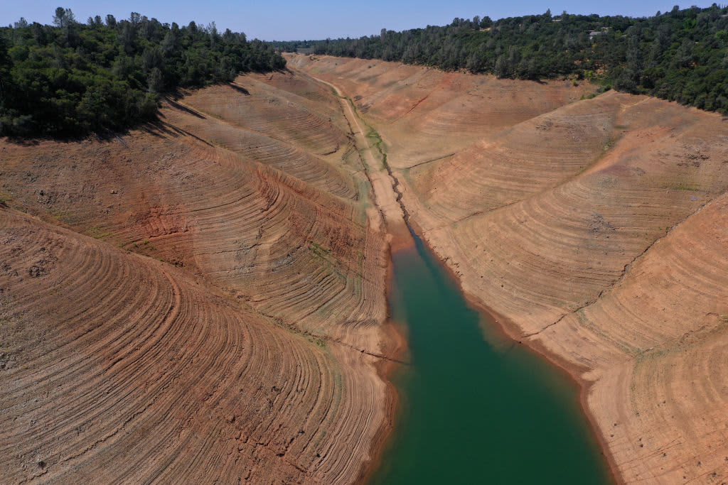
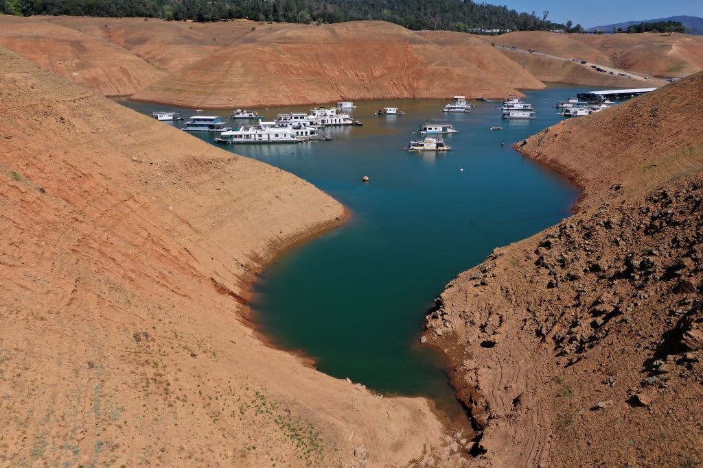
Prolonged hot and dry conditions over moths and years means water evaporates at a faster rate from reservoirs and the Sierra Nevada snowpack that feeds them. The snowpack usually melts in spring or early summer, then that water flows into the state’s vast storage and distribution system.
About a third of California's water supply comes from snow as it melts and flows down from the Sierra Nevada and the Shasta-Trinity mountain range in northern California.
California has more than 500 reservoirs, which were 50% lower than they should be at the start of June. These photos show the dramatic impact of the current dry spell at California’s lakes and reservoirs.
California's Mediterranean-style climate means the summers are always dry and the winters are not always wet. The state's reservoirs act as a savings account, storing water in the wet years to help the state survive during the dry ones.
Last year was the third driest on record in terms of precipitation.
Drought is generally defined as a period of drier-than-normal conditions resulting in water-related problems. That period can be days, weeks, months and years.
The term can have different meanings, depending on how water users are affected by water deficiencies. In a state of 40 million people, that's a lot of water users impacted in different ways by dry spells.
Individual decisions like reducing your water use on your lawn or not using animal products can make a long-term difference and prevent droughts, says behavioral scientist Sweta Chakraborty.
Droughts have been classified into the following:
Meteorological drought means a lack of precipitation.
Agricultural drought describes a lack of soil moisture.
Hydrologic drought indicates reduced streamflow or groundwater levels.
California recently went through a five-year event from 2012-2016. Other notable historical droughts included 2007-09, 1987-92, 1976-77, and off-and-on dry spells of more than a decade in the 1920s and 1930s.